
Observations of the Norwegian Fireball of June 7th, 2006
_______________________________________________
On June 7th, 2006 just after 00 UT (2 am Local time) a moderate sized meteoroid impacted the Earth’s atmosphere over the northern regions of
Using IRF infrasound array back azimuth intersections, a location for the sound source of: 68.860 oN, 22.204 oE is found.
Using long range observations, CTBTO stations I26DE (
Using the seismic peak arrival times, the initial infrasound observation at Kiruna and assuming the observed signals correlate to the fireball’s terminal flare (point source) a 4D position is found for this point which lies at: 69.203 oN, 22.396 oE at 43 km altitude occurring at ~00:06:28 UT.
________________________________________________________
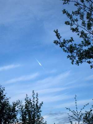
Photo by: Peter Bruvold (http://www.aftenposten.no/english/local/article1346411.ece)
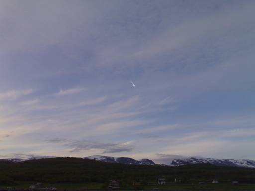
Photo by: Martin Lyngdal (http://www.astro.uio.no/ita/nyheter/ildkule06/ildkule06.html)
___________________________________________________________

As the closest infrasonic (sub-acoustic frequencies <20 Hz) instruments to the event the airwaves produced by the fireball were particularly strong. At the closest station Kiruna the signal is so large in amplitude that it saturated the instrument and so the initial part of the observation is clipped. The same is the case for the largest amplitude portions at Jamton and Lycksele as well. Three distinct pulses are clearly visible as they propagate across the length of
Beamforming Azimuths (degrees measured East from North)
Kiruna:
45 deg. (clipped portion of signal)
23.9 – 31.7 deg (unclipped portion of signal)
Jamton:
1.74 – 353.6 deg.
Lycksele:
14.63 – 17.93 deg.
9.1 – 9.97 deg.
__________________________________________________________
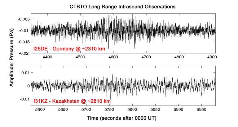
As part of the International Monitoring System (IMS) for the Comprehensive Nuclear Test Ban Treaty Organization (CTBTO) a series of 60 infrasonic microbarometer arrays are distributed around the world. Two of these instrument arrays also recorded the low-frequency sound from the June 7th fireball, I26DE in
Beamforming Azimuths (degrees measured East from North)
I26DE: 9.96 deg.
I32KZ: 332.9 deg.
________________________________________________________
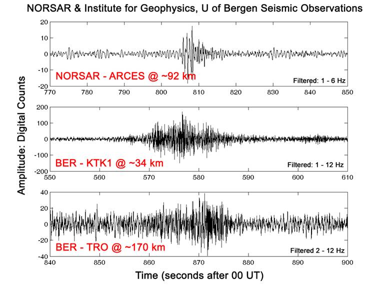
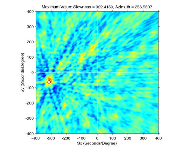
As the airwaves (sound) produced by the fireball propagated to the ground they were intense enough to couple with the Earth’s surface, causing the ground to move slightly. This movement was recorded by three seismic instruments located nearby. At Tromso (TRO) and Kautokeino (KTK1) this appears as a dispersed pulse, with hints of possibly the three peaks seen in the Swedish IRF data. At the NORSAR seismic array (ARCES), a 25 element seismometer array laid out in a circlular pattern just over 1 km in diameter, a complex wavetrain was also detected from the fireball. A single pulse with low frequency content (1 – 6 Hz) may be associated specifically with the airwave arrival. Similar to the infrasound, beamforming procedures can be used on this seismic arrival as it passed over the array, doing this a back azimuth of 258.6 deg. is found.
Location of the Fireball in Norway
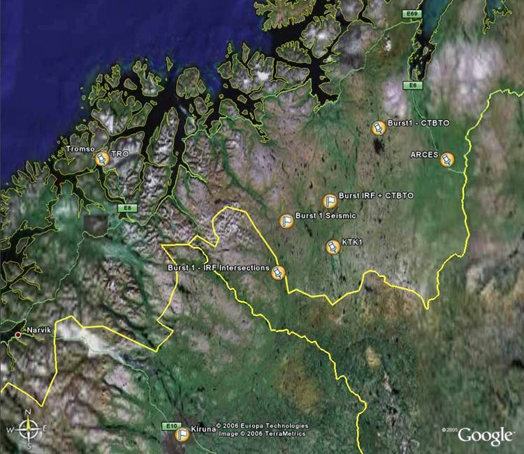
Using the azimuth intersections from the Swedish (IRF) infrasound data a location of 68.860 oN, 22.204 oE is found (Burst 1 – IRF intersections) just over the Norway-Finland border. The azimuth intersection from the long range CTBTO infrasound data places this position further to the NW at 69.782 oN, 24.246 oW (Burst1 – CTBTO). An average between these two positions places the terminal point of the fireball to the north of the KTK1 seismic station. A separate method that uses the arrival times of the seismic observations (and the initial observation at Kiruna) along with a reconstructed atmosphere model from June 7th, allows a 4D location for the terminal point to be found in a similar way in which earthquakes are located in the solid Earth. This position lies at 69.203oN, 22.396oW at an altitude of 43 km occurring at ~00:06:28 UT.
_________________________________________________________
For 7 days starting on June 14th, 2006 meteorite recovery efforts were attempted. Mike Mazur and a colleague, residents of

Mike Mazur: Searching the suspected meteorite strewn field in
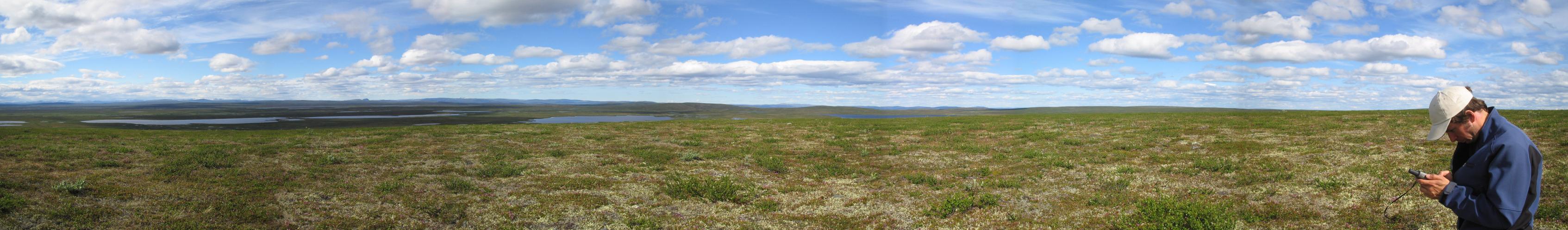
Panoramic view of the area for meteorite recovery